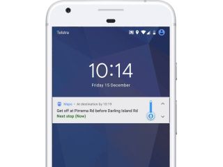
Google Maps now tells you when to get off at your bus stop

Trains and buses are how a lot of people make their daily commutes each and every day, and although Google Maps has already been able to show arrival times for this way of transportation, it's now getting a big upgrade with the new ability to tell you how much more time you have before you're at your destination.
When you're on a train or bus, you'll be able to look at Google Maps to see how many more stops you have until you get to where you want to go. A notification will show up on your lock screen telling you what stop to get off at and how many minutes until you get there, and this is also accompanied by a progress bar for your bus/train that moves in real-time.
In addition to this, Maps can also now give you turn-by-turn directions so you know exactly where to go to hop on your next ride.
I hardly ever use the bus or train since I live in a pretty rural area, but for my fellow city-dwellers, this sounds like something of a godsend. Enjoy!
Google Search and Maps will soon show restaurant wait times
Be an expert in 5 minutes
Get the latest news from Android Central, your trusted companion in the world of Android
Joe Maring was a Senior Editor for Android Central between 2017 and 2021. You can reach him on Twitter at @JoeMaring1.

